


Stravart: A Christmas Tree in Chicago
Run run Rudolph 🦌🛷🎅

On Christmas Eve, I embarked on a unique and exhilarating project: running to create Stravart—a GPS-tracked artwork—of a Christmas tree in Chicago. Combining physical endurance, artistic vision, and technical precision, this adventure was as much about the journey as the finished design. Let me take you through the process of bringing this festive creation to life.

What is Stravart?
Stravart, short for Strava Art, is the practice of using GPS tracking to create drawings by following specific routes while running, cycling, or walking. It’s an innovative way to merge exercise with creativity. The miles seem to fly by when you’re focused on replicating a design, and the results can be incredibly rewarding—a unique blend of art and physical achievement.
Ideation
Creating a piece of Stravart begins with choosing a theme. For this project, the Christmas tree motif was inspired by the holiday season. Themes can draw from world events, celebrations, or personal messages to make the art more meaningful.
Next, I analyzed Chicago’s map, looking for naturally occurring features like road shapes and land formations that could serve as the skeleton of the design. Scale is another critical factor. The route needs to be long enough to create a detailed drawing but manageable within the constraints of your activity, whether running or cycling. With an evening run in mind, I targeted a distance of 10 to 15 miles to simultaneously achieve high graphical detail without pushing my IT band too far.
I find maps fascinating in their fractal-like composition. Zooming into sections reveals increasingly granular paths, from major roads to alleyways. This level of detail can help achieve higher resolution in your Stravart, but it also requires meticulous planning.
Design
Once I settled on the concept, I began designing the route. The goal was to create a continuous circuit without any discontinuities. Breaking the art into subcomponents—such as the tree, a star-like shape on top, and the presents below—not only allowed for a logical progression, but resilience in execution. If I couldn’t complete the entire route, at least part of the design remains salvageable enough for presentation. I was especially in favor of drawing fine details—such as the crosses on the presents—after the objects’ outlines were completed. This way, if my endurance ran out beyond the half marathon point, the artistic idea of presents would still be conveyed.
For curves, I utilized several techniques: taking naturally curved roads, planning diagonally road crossings, and strategically cutting through grassy parks and parking lots. Sometimes, the drawing required tracing paths multiple times. Without a doubt, finding the intuition to minimize these duplicate traces was a true puzzle. I could hear my mind stepping through algorithms in real time.
Strava Premium was my primary tool for route design. Its waypoint functionality helped refine the route along common paths (via the Global Heatmap). At the same time, the platform enabled manual adjustments were necessary for paths that weren’t officially registered, or one-way streets I was willing to traverse on the sidewalk. GPS accuracy was a constant concern, especially in Chicago’s dense urban environment. Sharp edges and intricate details are challenging when signal interference can blur the drawing.

More on “Building the Global Heatmap” from Strava’s engineering blog—an impressive feat with many technical takeaways
Execution
Executing a Stravart design is as much about navigation as endurance. A few feasible navigation methods come to mind: preparing a detailed list of turn-by-turn directions; using a smartphone to overlay the drawn route with current GPS position; and my favorite—Running with a bike computer in my hand, bringing an intuitive navigation interface without draining my phone battery. It’s a nice hack, I’ll admit, but far from a need.
When it comes to the GPS tracking device, precision is paramount. Luckily, many smart watches and other activity-focused devices ship with multi-band GPS recording.
When repeating sections of the route, I was mindful of aligning the duplicate traces as cleanly as possible. This meant running along the same sidewalks and crosswalks. Interestingly, this tactic even withstands GPS inaccuracies. In theory, similar positions will incur similar environmental biases during GPS recording, thus finding consistency between the traces themselves.
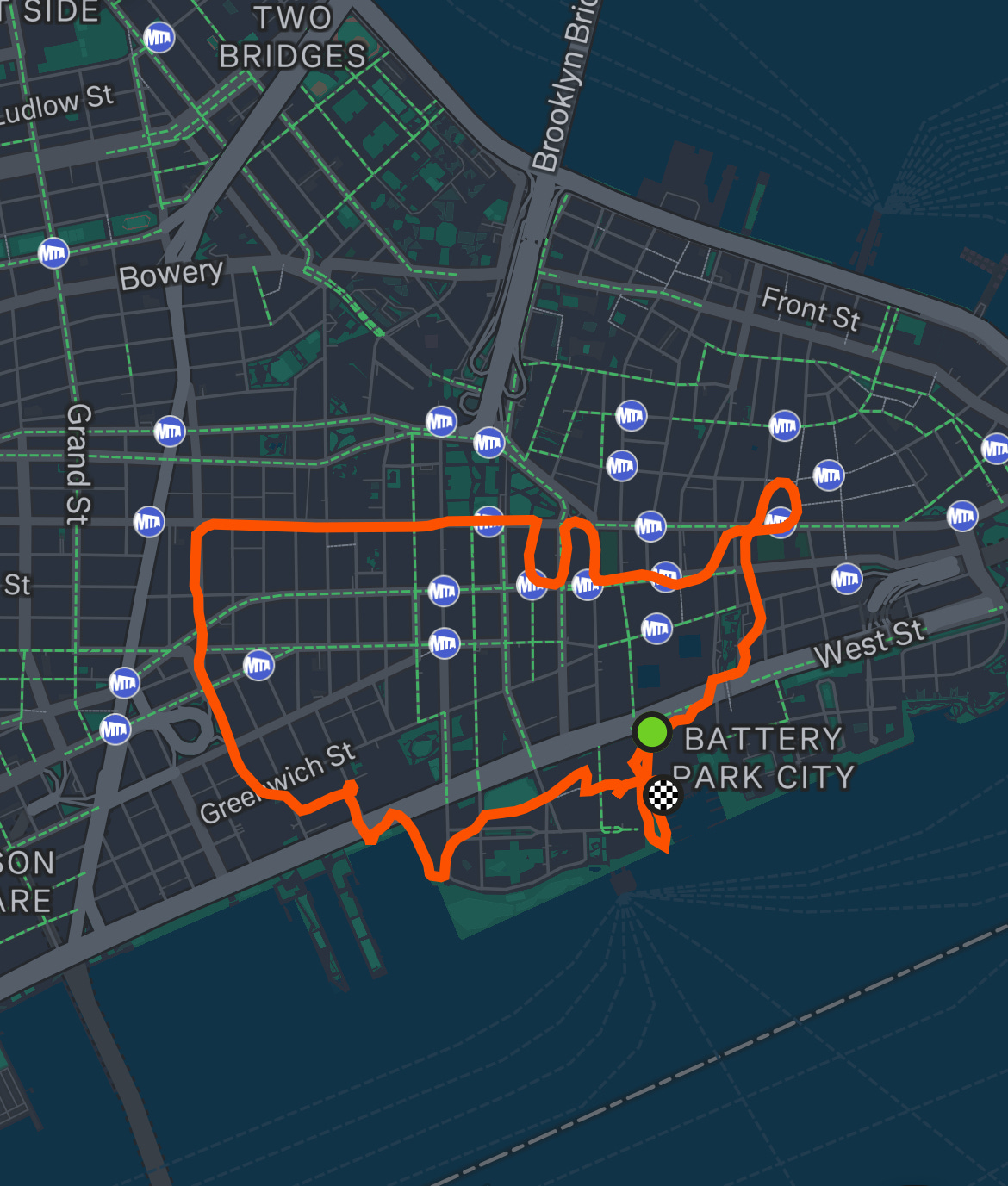
Frustratingly, detours are inevitable. Road closures, construction zones, gates and fences, among other unexpected barriers feel like a near-guarantee. Detours require quick thinking, relying on a mental projection of the map in bird’s-eye view to minimize the artistic damage stay on track. During a previous Stravart attempt in NYC, I had planned to trace elegant curves through green areas on the map, only to discover they were cemeteries with no public access.
By some stroke of luck, my attempt at the Christmas tree met no navigational pushback; Well, a few tunnels and stairs between levels, but I’ll take it.
Conclusion
Creating Stravart is a dynamic fusion of art, exercise, and problem-solving. My Christmas tree in Chicago stands as a testament to the creativity and determination this process demands. Whether you’re an athlete seeking a fresh challenge or an artist looking for a new medium, Stravart offers endless possibilities. So, lace up your shoes, pump up your tires, map out your vision, and let the roads become your canvas.